|
Reported Crop Circles for the State
of Indiana -
Etna Troy Township / Columbia City, Whitley County (July 14, 1996)
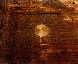
A 600+ long formation consisting of three separate sections formed across two hills in the same field. A dumbbell-type formation consisting of a 62 diameter circle with a ring with a pathway connected to a smaller circle. That smaller circle had three, separate swirled centers in which the highest level of increased radiation (~10x the normal background radiation level; not dangerous) found in the formation was located. The rings lay was described as looking like a flash-frozen fluid flow.
A smaller circle in-line with the other two was further down the slope of the hill.
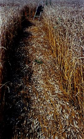
A 'V'-shaped pathway structure with a spur was located in alignment with the smaller circle located to the west; the pathway itself, although composed of straight lines, had a woven, wavy flattened lay.
Across the field to the South on the slope of another hill, was the third part of the formation; a large circle with a key and a small grapeshot circle off to the side.
Biophysicist W.C. Levengood of Pinelandia Labs, Grass Lake, Michigan reported significantly lengthened stem nodes and higher levels of magnetic material in the soil samples from the formation.
Crop
type: wheat
Source: personal investigation, Roger Sugden, W.C. Levengood
Photos: Jeffrey Wilson, Roger Sugden
|
|
City
/ County / Date:
- Dale,
Spencer County
(June 14, 1964)
- Cannelton,
Perry County
(June 17, 1964)
- Middlebury,
Elkhart County
(June 22, 1966)
- [Unknown]
(1972)
- Greenfield, Hancock County (November 8, 1978)
- Copley
Woods (?), (July 31, 1983)
- Middletown, Henry County
(May 27, 1987)
- Anderson / Middletown, Allen County (May 31, 1989)
- Warsaw, Kosciusko County
(June 27, 1990)
- Noblesville,
Hamilton County (June 7, 1994)
- Troy,
Spencer County
(June, 1994)
- Greensburg
/ Napoleon, Decatur County (September 11,
1994)
- Indian Village, Noble County
(July 1,
1996)
- Etna Troy Township / Columbia City, Whitley County
(July 14, 1996)
- Washington Center / Washington Township, Noble County
(July 20, 1996)
- Kewanna,
Fulton County
(August 7, 1996)
- New
Lake, Etna Troy Township, Whitley County (December 1996)
- Whitley County (July, 1996)
- Huntingburg, Dubois County (March 11, 1998)
- Spencer
/ Owen Valley, Owen County
(July 17, 2000)
- Bedford,
Lawrence County (December 12, 2004)
- Noble County (January 31, 2005)
- Albion,
Noble County
(April, 2005)
- Huntingburg, Dubois County
(June 26, 2006)
- Bedford, Lawrence County (September 13, 2008)
|